 Contents
THE FOUR SHIRE STONE
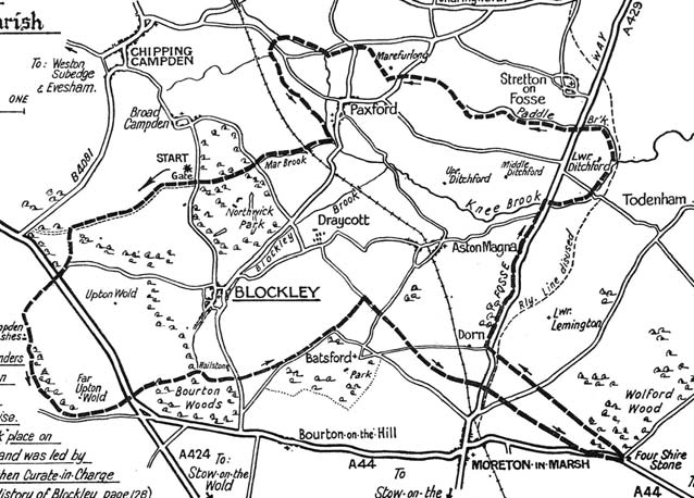
It must be assumed our Guild takes its name from the Four Shire Stone,
which stands about 2 miles out of Moreton-in-Marsh at the
junction of the A44 and the road that leads to Great Wolford
 .
If so, perhaps we
should take more than a passing (literally in the vast majority of
cases: who stops?) interest in it. Please note, too, that it is the
.
If so, perhaps we
should take more than a passing (literally in the vast majority of
cases: who stops?) interest in it. Please note, too, that it is the
Four Shire Stone
, not Four Shires Stone, as I suspect most locals
refer to it (I did, until I took the accompanying photo). Perhaps
Shires
is prevalent, because we are inclined to say Fourshirestone
,
i.e. quickly, with no gap between the words. As most of us know, the
Stone stood at the meeting place of Worcestershire, Gloucestershire,
Oxfordshire and Warwickshire when the Guild was formed in 1909, but 100
years on, it is now looks out on only three shires, Worcs having
departed. When did Worcs depart; and more to the point, how did it get
there, as it is now so far away?
I have an old map on the wall at home that shows the extent and details of Gloucestershire in the early 19th century. Although the map isn’t dated (it was obviously part of a set at one time by Henry Teesdale), it’s possible to date it to sometime between 1811 and 1847 from the features it shows and those it doesn’t. It does, of course, show the old county boundaries, upon which the meeting of Glos, Worcs, Oxon and Warks caused the Stone to have been erected.
What’s of interest from this map is that it shows Worcestershire not quite getting to where the Stone stands today. The nearest it reaches is about a couple of miles to the west of the Stone, immediately north of Moreton. Glos, Oxon and Warks are shown to meet at the Stone, as they still do. The Worcs bit was the parish of Blockley, which was detached from the main body of the county. Some significant county changes occurred throughout the country in the 1930s to clean up the numerous detached bits of counties that existed in neighbouring counties and Blockley parish was transferred to Gloucestershire in 1931.
So
how did the Stone become the Four Shires Stone if, in strict truth,
only three counties met at that point? The answer was partly provided
in a book I read recently: Blockley through twelve centuries
by Mr H E M Icely. I hope the Blockley Antiquarian Society (with which the
copyright is vested) will excuse me if I reproduce a map from this
book, which shows the parish boundary of Blockley as it existed prior
to the county boundary change of 1931. It shows the parish included a
finger
of land to the Stone, from Dorn across the north side of
Moreton. The book records that Blockley parish included Dorn until
1935, when Dorn was transferred to Batsford parish.
You will note I said the answer was partly provided by Mr Icely’s book.
So what was the other part? In preparing this article I looked up Four
Shire Stone
on the internet, to discover when it was erected. I
couldn’t find a definitive article of the Stone’s history, just bits
here and there. There were photos, and I scoffed at the person who said
Worcestershire was removed at the county boundary changes of the early
1970s. I noted some chap said Worcestershire’s inclusion at the Stone
was due to the parish of Evenlode, and I wondered whether he was wrong,
too, because my Teesdale map doesn’t show Evenlode as part of
Worcestershire. It seems to show it in Oxfordshire at that time – but
being a map of Gloucestershire, the non-Glos bits aren’t too specific.
Evenlode is now in Glos, of course.
Was this chap wrong about Evenlode being in Worcestershire? It seems not. I remembered I had a book that contained facsimile prints of county maps of England by Thomas Moule, who originally published the originals in about 1830, roughly about the same vintage as the Teesdale map. Now, Moule’s Worcestershire map shows very clearly Evenlode parish being in Worcestershire at that time, and that it extended right the way up to the Four Shires Stone. Mr Icely’s book records the Bishop of Worcester held the Manor of Blockley in the Domesday Survey of 1086, and attached to the manor were Evenlode, Daylesford and Icomb; so that’s how these areas became Worcestershire originally (and are shown as such on Moule’s map). Oddly, Blockey parish’s finger isn’t shown by Moule; it may have been too thin to show it at the scale of the map. It’s possible the Bishop wanted to access Evenlode entirely within his own land and created the finger to do this. We may never know. I have no information about when Evenlode parish moved to Glos, but I’d guess it was at the same time as Blockley: 1931.
The 1930s boundary changes wrought large changes in other places, of course. The Moule maps show Shipston on Stour as being in Worcestershire, which is confirmed by its entry in Walters’ Church Bells of Worcestershire, published 1925, whereas Hinton-on-the-Green was in Gloucestershire and has no entry in that book. (Blockley also appears in CBoW – and Evenlode, too.)
When I took the photos below, it was the first time for many, many years I’d stopped to look around the Stone. It now leans slightly towards the minor road. It was involved in a car accident some years back (it was reported the Stone was quite stationary at the time…) and significant damage occurred to it. I believe the Evesham Journal carried some photos of the accident. Clearly, repairs were undertaken. Perhaps this is the reason for the lean? The Stone looks in fairly good condition, but this might be due to the repair work (of which there are no obvious signs now). It would be interesting to know which county has the responsibility for its upkeep, as it is sited on part of the public highway. Perhaps all the three remaining counties do. It would be interesting to know whether Worcs still has some ancient responsibility. Answers on a postcard, please…..
The big mystery remains though – and I can find no information anywhere to solve it. Who built the Four Shire Stone? and when? Does anyone know? If somebody knows the answer to these two simple questions, could they pass it on to me, please?
CMP
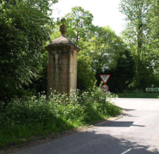
Note slight lean towards the Wolford road
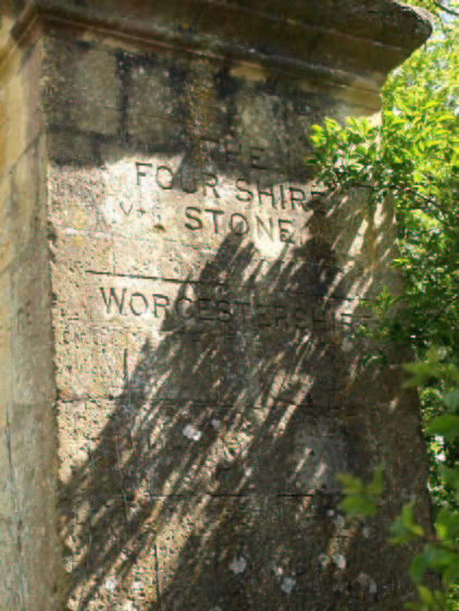
The Four Shire Stone
(The Worcestershire face)